
ENVIRONMENTAL WARFARE: 1991 PERSIAN GULF WAR
Professor Paul R. Baumann
Department of Geography
State University of New York
College at Oneonta
Oneonta, New York 13820
COPYRIGHT © 2001 Paul R. Baumann
INTRODUCTION:
The Persian Gulf War of 1991 brought serious environmental damage to major portions of the Middle East. On January 21, 1991, a few days after the Coalition Forces launched an air campaign against Iraq, the Iraqi military forces in Kuwait opened valves at the Sea Island oil terminal near Kuwait City and released large quantities of crude oil into the Gulf, an act of environmental warfare. The oil moved southward and began to accumulate on the north coast of Saudi Arabia, endangering the fragile intertidal zones and mangrove forests and destroying wildlife habitats. The spoiled shallow coastal areas normally provided feeding grounds for birds and feeding and nursery areas for fish and shrimp. Because the plants and animals of the seafloor are the basis of the food chain, damage to the shoreline had consequences for the whole shallow-water ecosystem, including the multimillion-dollar Saudi fisheries industry. During this period various Saudi governmental agencies as well as oil companies and other nations started the difficult task of trying to measure the amount and location of the oil in order to determine where to concentrate resources to combat it. This instructional module outlines a simple approach, using satellite imagery and basic mathematical logic, to identify the amount and location of an oil spill. Major oil spills occur every year throughout the world impacting hundreds of environments. The approach presented in this module might assist those organizations involved in trying to protect areas against damage from oil based disasters.
The purpose of this instructional module is to present a methodology to determine the size of an oil spill. This methodology employs the use of a Landsat TM data set, which covers a study area of 512 by 512 pixels. The data set depicts conditions present on March 4, 1991 at Dawhat Ad Daffi, near the city of Al Jubail on the Saudi coastline.
BACKGROUND:
Persian Gulf
The Persian Gulf, also called the Arabian Gulf by the Arab countries, is a kidney-shaped water body orientated in a northwest to southeast direction. It is approximately 917 km (570 miles) long with its greatest width being 338 km (210 miles). The Shatt-al- Arab river, the Gulf's main source of fresh water, flows primarily from Iraq into the northern end of the Gulf. The Tigris and Euphrates, two of the largest river systems in the Middle East, merge together to form the Shatt-al-Arab river shortly before it enters the Gulf. At its southeast terminus, the Gulf is linked to the Gulf of Oman and eventually the Arabian Sea and Indian Ocean via the Strait of Hormuz. The Gulf covers 233,100 km2 (90,000 square miles), an area equal in size to New York State and Pennsylvania combined, and contains 8630 km3 (2070 cubic miles) of water. Figure 1, a mosaic of NOAA AVHRR scenes acquired on September 1 and 6, 1990, shows the Persian Gulf and surrounding landforms.
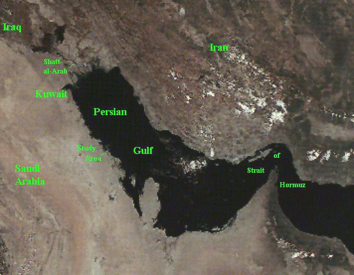
FIGURE 1
In terms of fresh water intake the Gulf receives an annual average of 34km3 from precipitation and 37km3 from river runoff. The precipitation is concentrated mainly in the winter months, the period of lowest evaporation. When spread out over the Gulf's entire surface area, the fresh water intake accounts for a water layer of nearly .32m (12.6 inches) in depth, which represents only a minor portion of the Gulf's total volume. The Gulf's average depth is approximately 36m (118 feet)(Ackleson et al., 1992).
Due to the region's high temperatures, the Gulf loses an estimated
326km3 of water per year to evaporation. The excess of evaporation
over fresh water intake creates a circulation where more water
(3365km3 per year) flows into the Gulf at its surface than exits
(3110km3 per year) it at the lower depths (Ackleson et al., 1992).
It also creates a situation where the water in the Gulf is nearly
one and a half times more saline than the oceans. The Gulf's
counterclockwise current moves the saline water coming through the
Strait of Hormuz along the coast of Iran and fresh water and
sediment from the Shatt-al-Arab along the very shallow Saudi
coastline, providing an ideal habitat for algae, which is the
primary link in the food chain for the Gulf's principal fisheries.
These shallow areas have also been the final resting places for oil
from spills. An estimated quarter of a million barrels of oil
pollute the Gulf each year and with the Gulf's circulation
imbalance it takes more than five years to flush contaminated water
through the narrow Strait of Hormuz.
The Study Area
The study area relates to a 512 by 512 pixel image dealing with a section of the Saudi coastline situated 322km (200 miles) southeast of Al Kuwayt (Kuwait City) and centered on Dawhat Ad Daffi (Ad Daffi Bay). Figure 2, a TM Band 4 image taken on March 4, 1991, identifies the study area and certain geographic features. The bay is quite shallow with its greatest depths not exceeding 5m (16 feet). The elongated land body near the bottom edge of the image is Gurmah Island. A portion of what is generally referred to as Abu Ali Island appears on the east side of the image. Actually, this land body consists of two islands, Abu Ali and Al Batinah. It is Al Batinah, which appears on the image and not Abu Ali. The city of Al Jubail is located just south of the study area. The west side of the image shows the Saudi coast with several inlets. This study area, especially Ad Daffi Bay and Abu Ali Island, played a key role in trapping and blocking the oil flow during the Persian Gulf War so that oil did not move farther south. These land features have functioned in this manner with previous oil spills coming from the northern portions of the Gulf. Figure 3, a color composite TM 7,2,1(RGB) image acquired on February 16, 1991, provides an overview of the study area and surrounding region.

FIGURE 2

FIGURE 3
Ad Daffi Bay and Abu Ali Island experienced the greatest pollution, with the main effect of the spill concentrated in the mangrove areas and shrimp grounds. Large numbers of marine birds, such as cormorants, grebes, and auks, were killed when their plumage was coated with oil. The beaches around the entire bay shoreline were covered with oil and tar balls. Gurmah Island was of particular interest to the groups trying to protect the bay's environments. It has a large stand of rare dwarf black mangroves situated along its southwest edge. Along with these trees grows an asparagus resembling pneumatophore, the roots of which allow the mangroves to respire. Many of these pneumatophores became covered with oil resulting in the eventual death of adjacent trees. Protective booms were placed across the tidal channels but they did not completely control the flow of oil among the trees. The linear features around Gurmah Island, which can be seen in several of the TM bands, are not the protective booms but relate to areas dredged to allow boats passage around the island. The booms were deployed close to the shore and cannot be detected on the imagery. The image below shows the dredged areas as well as the complex water patterns in Ad Daffi Bay related to its currents and bathymetry.

FIGURE 4
Al Jubail
Immediately south of the study area covered is the city of Al Jubail (Jubayl). In the early 1970s, Al Jubail, an ancient fishing and pearling community of some 8,000 people, was selected by the Saudi government to become a major industrial city, which should reach a population size of 350,000 by the year 2000. Sixteen primary industries have been or are in the process of being built in Jubail. These industries include factories producing steel, gasoline, diesel fuel, petrochemicals, lubricating oil, and chemical fertilizer. Jubail is basically a new, planned city, which covers a huge area of nearly 365 miles and was designed, with the aid of remote sensing, by the San Francisco based company called Bechtel. To handle this industrial development and population growth, good port facilities and fresh water were needed. Sixteen berths were constructed to form Jubail's commercial port, and an industrial port with direct access to the open sea was built at the end of a six mile long causeway linking the port to the mainland. Fresh water was obtained by building the world's largest desalination complex just south of old Jubail. Thus, from an economic perspective, Saudi Arabia was quite concerned about protecting Jubail from the oil spill.
Pre-War Conditions
Between 1978 and 1991, prior to the Persian Gulf War, five major oil spills had occurred in the Gulf, each involving more than a quarter of a million barrels of crude oil and each being larger than the 1989 Exxon Valdez spill. See Table 1. The largest of these spills was associated with a well at Nowruz, Iran that resulted in 1.9 million barrels of oil being dumped in the northern section of the Gulf. Also, a considerable amount of industrial spillage and natural oil seepage occurs in the Gulf each year. Estimates range from 250,000 to 3 million barrels per year (DeSouza, 1991;Ackleson et al., 1992). This is the environmental price, which the Gulf must pay to be the world's major oil highway.
| DATE |
LOCATION |
MILLION BARRELS |
| 05/25/1978 | Well 126, Iran | 0.7 |
| 08/20/1981 | Kuwait Petroleum Tank | 0.7 |
| 02/04/1983 | Nowruz, Iran | 1.9 |
| 12/10/1983 | Qatar | 0.3 |
| 08/15/1985 | Khar Island, Iran | 0.5 |
In 1991, several Gulf nations, under the U.N. Intergovernmental Oceanographic Commission, established the Regional Organization for Protection of Marine Environment (ROPME) (Ackleson et al., 1992). ROPME identified a portion of the Persian Gulf as the ROPME Sea Area and sought help from the international scientific community to determine the impact of the 1991 Gulf War oil spill on the marine environment. On February 26, 1992, an international team of scientists started a 100 day survey of the ROPME Sea Area, concentrating its efforts on mapping the shallow marine habitats around Abu Ali Island, a portion of the study area. The team found a massive asphalt surface on the beaches of the island as well as along sections of the Saudi coast north of the island. The asphalt surface ranged over 20m (65 feet) and 0.2m (8 inches) thick. This surface condition pre-dated the 1991 War and indicated the long term effect of the Gulf constantly absorbing oil spills from a variety of sources. Overlaying this asphalt surface was an oily sand layer, which resulted from the 1991 Gulf War oil spill. The team also found that this oil spill seemed to have had its greatest effect on the intertidal plant and animal communities in the Ad Daffi Bay. It might be difficult to separate on the imagery old oil spill areas from the 1991 spill.
In spite of the numerous past oil spills, especially during the Iran-Iraq conflict, the natural seeping of oil, and the large number of huge oil tankers, the Gulf has remained an active and unique ecosystem and functions as a significant food source, an important recreation area, a major habitat for endangered species, and a key flyway for migratory birds. How well and how quickly the Gulf will recover from this most recent attack on its ecosystem is not yet known. Comparisons have been made between the 1991 Gulf oil spill and the highly publicized Exxon Valdez spill. However, the Valdez spill was considerably smaller at 240,000 barrels and occurred in a subpolar, rocky-shored, and highly mixed water environment. The Gulf with its tropical temperatures and sandy low shores is a much different water environment than Prince William Sound, Alaska. It is also a much larger water body with a long flow-through rate, about five years, and its water is described as placid and very warm. A more analogous environment with a history of oil spills would be the Gulf of Mexico. An older but more comparable example would be the 1978 IXTOC spill in the Gulf of Mexico, which created a spill of roughly 3.3 to 10.2 million barrels (U.S. Office of Technology Assessment, 1990).
1991 Gulf War
On January 21, 1991, two days after the Coalition forces launched an air campaign against Iraq for invading Kuwait, Iraqi forces opened valves at an offshore oil transshipment terminal and offloaded crude oil from moored tankers, creating a huge oil spill in the Gulf (Congressional Report, 1992). The spill was first spotted on January 24th by Saudi Arabia's Meteorological and Environmental Protection Agency. Baghdad immediately reported that "American aircraft attacked two Iraqi oil tankers loaded with oil and the attack led to the outflow of large quantities of oil" (Reuters, 1991). However, the main source of oil appears to have been Kuwait's off-shore Sea Island terminal and on January 26, U.S. Air Force F-111s attempted to stop the oil flow by bombing the terminal's shoreside pipelines and manifold complex. This bombing did not terminate completely the flow from the facility and it was determined that other sources were contributing to the spill. Other sources included tankers near Mina Al Ahmadi, a damaged refinery south of Mina Al Ahmadi, the Iraqi Mina Al Bakr terminal, and tankers anchored north of Kuwait's Bubiyan Island.
Initial estimates placed the size of the spill at 10 million barrels, but later and apparently more accurate figures ranged between 4 and 6 million barrels (Congressional Report, 1992). Combined, the five previous major spills within the Gulf accounted for 4.1 million barrels, equivalent to the minimum estimated amount released during the Gulf War. Oil continued to be discharged into the Persian Gulf until at least late May, 1991. Practically all of the released oil drifted southwest along the Gulf coast due to the prevailing north winds. However, for the initial two weeks the winds were unseasonably soft and from the southeast which kept the oil from moving to the southwest and provided valuable time to prepare for it. Apparently half of the oil evaporated under the Gulf's warm temperature, and about 1.5 million barrels were recovered by the Saudis. The northerly winds along with persistent coastal sea breezes pushed the remaining .5 to 1.5 million barrels ashore jeopardizing Kuwaiti and Saudi desalination plants, fouling nearly 400 miles of coast line, inundating salt marshes and killing wildlife. The oil might have drifted further south along the Saudi coast if the hook-shaped Abu Ali Island had not blocked the flow and protected the areas south of the island (Ackleson et al., 1992).
Landsat Thematic Mapper (TM) imagery as well as data sets from other satellites were very useful in detecting and monitoring the spilled oil and its flow. The TM mid-infrared bands (Bands 5 and 7) separated the oil's strong reflectance from the low reflectance associated with water. Three weeks after oil was released from the Sea Island Terminal, a February 8 Landsat image showed the oil slick, basically intact, moving down the Saudi coast some 160km (100 miles) south of the terminal. The February 16 Landsat image depicted a slick about 60km (37 miles) long, which had traveled 240km (150 miles) south of Kuwait. The image also indicated that the slick was breaking up as it entered Ad Daffi Bay and came into contact with Abu Ali Island. TM images recorded on March 4, 5, and 19 showed that the oil had washed ashore. Ninety different Landsat images were acquired of the Persian Gulf region between January 1 and August 26, 1991, demonstrating the key role played by satellite remote sensing in analyzing environmental problems. Hundreds of other images were available from other non-military satellites and Space Shuttle flights during this period (DeSouza, 1991).
This act of environmental warfare was accompanied by the ignition of Kuwaiti oil wells in February, 1991 when the ground war started. Some 732 wells were damaged with 650 being set aflame, creating enormous smoke plumes, and 82 being opened, causing huge basins of oil. An estimated 3-4 million barrels of oil per day were burned; the United States, as a comparison, imports nearly 5.6 million barrels per day (Congressional Report, 1992). In addition to the apparent environmental damage done by these fires, considerable oil fallout from the smoke plumes affected land and water areas and contributed to the oil spill problem within the Gulf. It was estimated that this black oily rain nearly doubled the amount of oil spilled directly into the Gulf (Ackleson et al., 1992). Deliberate environmental warfare is not new in the annals of war but the world has never experienced a situation at the magnitude of what occurred in the Persian Gulf.
ANALYSIS:
In order to establish an approach to determine the geographic extent and location of the oil spill, this analysis is based on understanding and employing the spectral characteristics of the various bands in the Landsat data sets. Also, simple mathematical operations are applied rather than using sophisticated statistical procedures, which make it easier for novices to image processing techniques to understand the exact analytical steps being employed.
After loading the seven TM bands into the software package, the next step was to stretch each band to make full use of the absolute data range (1-250), and thereby, create more detailed images. Figure 5 demonstrates the difference between the regular recorded data and the stretched data of an image. Most of the time the dynamic range, that is the range of the recorded values, of a band does not equal the full extent of the absolute data range. The software provided the ability to display the statistics and histograms for each band. In this analysis the minimum and maximum values were used to stretch the data. For example, if a band had a minimum and maximum data value of 20 and 155, respectively, these values were converted to 1 and 250 and all of the values in between were stretched accordingly. Rather than automatically using the minimum and maximum values associated with a band, one can establish other values within the dynamic range to be used as the minimum and maximum levels for the stretching procedure, and in the process, center in on a certain portion of the data range to enhance.

FIGURE 5
The three visible TM bands detected many different features in the water. However, without first hand knowledge of the area, it was not clear if these features were natural channels in the water, various water depths, oil slicks, or some other phenomenon. The visible bands showed considerable variation within the water but without knowing, which features were oil slicks, these bands were not very helpful. In band 4, a near infrared band, the water was nearly solid black. Little differentiation was seen within the water, but the separation between land and water was very clear. Basically the same situation occurred in band 5 except for one major difference. Areas with higher reflectance values than normal water were detected in Ad Daffi Bay. The phenomenon creating these values was probably something sitting on the surface of the water, which the infrared portion of the spectrum covered by band 5 was able to detect and separate from water. This phenomenon was the oil. The same situation was observed in band 7, which relates to the mid infrared area of the spectrum but the oil was not as well defined as in band 5. Figure 6 identifies the oil slicks in band 5.

FIGURE 6
With the aid of the software package it was possible to sample the value ranges within band 5 for the oil slick areas, the normal water within the bay, and the surrounding land. It was discovered that the large slicks had reflectance values ranging in the 70s; whereas, the edges of the slicks and smaller slicks had values from the low 30s to the high 60s. Normal water values were very low and a wide range of values existed over the land. With this information the band 5 can be sliced or divided into four classes: water (1-30), light oil (31,68), heavy oil (69,80), and land (81,250). This classification process is known as density slicing and it creates a classified image as well as a count of the number pixels in each class. Knowing that each pixel covers an area of 30 meters by 30 meters enables one to convert these counts into several different areal measurements. See Table 2.
| Surface |
Pixels |
Acres | Sq. Mi. | Hectures | Km2 |
| Water | 150,851 | 33,548 | 52.41 | 13,577 | 135.77 |
| Light Oil | 19,199 | 4,270 | 6.67 | 1,728 | 17.28 |
| Heavy Oil | 19,052 | 4,237 | 6.62 | 1,715 | 17.15 |
| Land | 73,042 | 16,244 | 25.38 | 6,574 | 65.74 |
The classified image has four colors that relate to the four classes. Water is shown in blue, light oil in red, heavy oil in yellow, and land in dark green. See Figure 7. In examining the image it was apparent that a problem exists. A number of land surfaces, which were situated away from the coastline were classified as being covered by oil. To rectify this condition, it was necessary to find a way to separate the apparent oil surfaces over the water areas and along the coastline from the misclassified oil surfaces over the land areas. The misclassification was the result that both areas had the same reflectance values in Band 5.

FIGURE 7
As previously stated Band 4 clearly separated water from land and showed water as a solid black area with little variation, which indicated low reflectance values. If bands 4 and 5 were added together, pure water areas, which have low reflectances in both bands should have low values and land areas, which have high reflectances in both bands should have high values. However, when the relatively high oil reflectance values in band 5 are added to the low water values in band 4, the new values should separate the oil within the water from the false oil conditions on the land.

FIGURE 8
Using the arithmetic option within the software package, the two bands can be added together to form a new image. Figure 8 provides the result of this arithmetic operation. A negative gray scale was used to highlight the oil slicks. Employing the same density slicing procedures used previously, the new image was classified based on the four surface classes. However, by merging the two bands, the data range for each of the four classes had to be redetermined. The new data ranges were: water (1-25), light oil (26-40), heavy oil (41-53), and land (54-250). Note that the adding of the two bands together resulted in the rescaling of the image to the absolute data range.
| Surface |
Pixels |
Acres | Sq. Mi. | Hectures | Km2 |
| Water | 143,499 | 31,913 | 49.86 | 12,914 | 129.14 |
| Light Oil | 7,188 | 1,598 | 2.49 | 647 | 6.47 |
| Heavy Oil | 6,546 | 1,456 | 2.27 | 589 | 5.89 |
| Land | 104,911 | 23,331 | 36.45 | 9,442 | 94.42 |
The pixel counts from this classification, as shown in Table 3, were noticeably different from the first classification indicating more land and less oil. Figure 9 shows the geographic results of this classification. This image places most of the oil in open water areas or along the coastline. Very little oil is indicated as being inland. This is a much improved classification over the previous one. However, it is possible that a yet better classification can be obtained.

FIGURE 9
Rather than directly using the raw data associated with Band 4, better results might be ascertained by first conducting a density slice classification on Band 4 before adding it together with Band 5. A two-level density slice classification was done on the stretched version of Band 4. The two levels related to water and land. As in the case of the other density slice classifications conducted in the study, it was first necessary to determine the data ranges for both water and land. These ranges were 1-34 for water and 35-250 for land. The density slice classification produced a new image file, which had only data values of "1s" (water) and "2s" (land). To add this new image file, with such a small data range, to Band 5 would only create results similar to the first classification. To overcome this problem, the new image file was stretched. All the land pixels with a value of 2 now had a value of 250. The water pixels continued to have a value of 1. By having an image with one distinct value for water and one for land creates less confusion than an image with a range of values for water and land.
| Surface |
Pixels |
Acres | Sq. Mi. | Hectures | Km2 |
| Water | 137,175 | 30,507 | 47.67 | 12,346 | 123.46 |
| Light Oil | 6,912 | 1,537 | 2.40 | 622 | 6.22 |
| Heavy Oil | 4,795 | 1,066 | 1.66 | 432 | 4.32 |
| Land | 113,262 | 25,189 | 39.35 | 10,193 | 101.93 |
In the addition process between the new Band 4 picture and Band 5, water is pushed to the bottom of the data range and land to the top of range. The oil over the water falls somewhere in the lower section of the data range but above regular water. What was being shown as oil on the land in the previous is now grouped with the land and can be separated from the oil on the water. The density sliced ranges used on the image generated by adding the classified and stretched Band 4 image to Band 5 were: 0-8 (water, blue), 9-24 (light oil, red), 25-45 (heavy oil, yellow), and 46-250 (land, green). Table 4 and Figure 10 display the results of this third classification.

FIGURE 10
Figure 11 compares the results of three classifications within two sections of the study area. The first classification, which was based just on the stretched version of Band 5, indicates too much oil over the land with some of the supposed oil deposits being quite a distance inland. The second classification, which was produced by adding the stretched versions of both Bands 4 and 5, corrects most of this problem. However, some patches still exist and a fair amount oil is found along the coastline. Some of the oil being indicated along the coastline might be actual oil from this oil spill or an earlier spill(s). The third classification, which was created by putting together a classified and stretched image produced from Band 4 with the stretched version of Band 5, shows very little oil on the land. This classification produced the best results. One might develop a better product by changing the density sliced ranges for the four surface classes. As is often the case one is not likely to obtain a perfect classification, which is one-hundred percent accurate but one attempts to attain the best possible results.

FIGURE 11
REFERENCES:
Ackleson, S.G., D.E. Pitts, K.D. Sullivan, and R.M. Reynolds. 1992. "Astronaut Observations of the Persian (Arabian) Gulf During STS-45." Geocarto International No. 4, pp.59-68.
Canby, T. 1991. "After the Storm." National Geographic Vol.180, No. 2: 2-33.
De Souza, A. 1991. "The Environmental Consequences of the Persian Gulf War: 1990-1991 Remote Sensing Datasets of Kuwait and Environs." National Geographic Society: Committee for Research and Exploration 7 (Special Issue): 48p.
Johnson, T. 1991. "War Within A War: Fighting the Gulf Oil Spill." Aramco World Vol. 42. No.3: 35-39.
"Landsat Imagery Reveals Persian Gulf Oil Slick." Landsat Data Users Notes. Volume 6, Number 1, p. 8.
Narumalani, S., J. Jensen, M. Hayes, J. Michel, T. Montello, and J. Robinson. 1993. "Gulf War Legacy: Using Remote Sensing to Assess Habitat in the Saudi Arabian Gulf before the Gulf War Oil Spill." Geo Info Systems June, pp.38-41.
U.S. Committee on Merchant Marine and Fisheries. 1992. The Environmental Role of the National Oceanic and Atmospheric Administration and the U.S. Coast Guard in the Persian Gulf Conflict Congressional Report 135p.
U.S. Office of Technology Assessment. 1990. Coping with an Oiled Sea: An Analysis of Oil Spill Response Technologies 70p.
U.S. Senate Committee on Environment and Public Works. 1992. The Environmental Aftermath of the Gulf War Congressional Report 74p.